Perth Airport phone information 61 8 94788888
Use the Map of Perth to get direction from Perth airport to your Perth destination. Zoom out to show other airports in Perth or Australia and or the relative distance from Perth airports to other Perth locations.
By Road to Perth AirportS
Use the Great Eastern highway to get in and out of both the Perth domestic airport and Perth international airport. Lookout for large green airport street signs. Users of Perth international airport via the Perth CBD should also travel via Tonkin Highway and Horrie-Miller Drive near the Perth international airport. Perth airports are about 8Km distant from the Perth CBD.
Big Tourist Map of Perth Airport
Taxis to Perth Airport, Shuttle buses to Perth Airport and Public Buses to Perth Airport run frequently except Public buses on Sundays.
Perth Airport transport operators are invited to list their details here.
4 Perth Airports:
- Perth International Airport. Terminal 1 Arrival and Departure Information. Get to Perth International airport by turning north off Horrie-Miller Drive. Perth international airport terminal has high speed wireless internet hotspots.
- Perth Domestic AirPort for interstate flights. Get to Perth Domestic AirPort, turn east off Great Eastern Highway.
- Jandakot Airport, Perth: Light aircraft airport. Busiest airport in Australia. Jandakot airport is about 30 minutes drive south from the Perth CBD. John Grummels was the first pilot to land at Jandakot airport in a plane Charter flight passenger airport terminal for INTERNAL Western Australian flights. Used by smaller Western Australian charter flight operators for fly-in-fly-out miners etc. Get to Northern Perth airport: turn east off Great Eastern Highway. Northern side of Perth domestic airport.
Charter flight airline operators at Perth Domestic airport:
- Network
- Sippers
- SkyWest
- Maroomba Airlines
Flight Movements of Busy Australian Airports Including Perth Airport
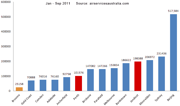
Domestic domestic passengers travelling through Perth Airport statistics.
More information about Perth Airport

Flight Radar Perth showing flights in and out of Perth live on a Google map.
Best Things to Do Perth WA.
Advertise online by SEO Perth expert.
Good Restaurants in Perth
Need Perth escort services pickup from Perth airport?
Accommodation Near Singapore Airport
Accommodation Near Bangkok Airport
Latest Australian News Headlines